10th social Science digital Guide
10th social Science Geography Chapter-1 - INDIA - LOCATION, RELIEF AND DRAINAGE Book solutions Question and answer. You can Download PDF Class 10th Social Science notes,Guide for tamil medium and English medium. Tamil nadu samacheer Kalvi New syllabus 2020-2021
Dear students and visitors we provide Tn samacheer Kalvi new text book solutions (question and answers) for all subjects 1st,2nd,3rd,4th,5th,6th,7th,8th,9th,10th,11th,12th std textbook solutions .Tamil,English, maths,science, social science 11th,12th maths solutions and chemistry, physics book solutions also we provide. These tn samacheer book solutions (question and answer) prepared by well teachers team.kindly give your valuable suggestion for our website what study materials you want for your study purpose. Leave your comment free full mind .
10th social science Geography unit-1 INDIA - LOCATION, RELIEF AND DRAINAGE Guide Book back question and answer Solutions
Choose the Correct Answer
1. TheNorth-southextentofIndiais__________.
a) 2,500 km
c) 3,214 km
b) 2,933 km
d) 2,814 km
Ans: c) 3,214 km
2. The Southernmost point of India is __________.
a) Andaman
c) Indira Point
b) Kanyakumari
d) Kavartti
Ans: c) Indira Point
3. The extent of Himalayas in the East-west is about __________.
a) 2,500 km
c) 800 km
b) 2,400 km
d) 2,200 km
Ans: a) 2,500 km
4. __________ river is known as ‘Sorrow of Bihar’.
a) Narmada
c) Kosi
b) Godavari
d) Damodar
Ans: c) Kosi
5. Deccan Plateau covers an area of about __________.
a) 8 lakh
c) 5 lakh
b) 6 lakh
d) 7 lakh
Ans: d) 7 lakh
6. A landmass bounded by sea on three sides is referred to as __________.
a) Coast
c) Peninsula
b) Island
d) Strait
Ans: c) Peninsula
7. The Palk Strait and Gulf of Mannar separates India from __________.
a) Goa
c) Sri Lanka
b) West Bengal
d) Maldives
Ans: c) Sri Lanka
8. The highest peak in South India is __________.
a) Ooty
c) Anaimudi
b) Kodaikanal
d) Jindhagada
Ans: c) Anaimudi
9. __________ Plains are formed by the older alluviums.
a) Bhabar
c) Bhangar
b) Tarai
d) Khadar
10. Pulicat Lake is located between the states of __________.
a) West Bengal and Odisha
c) Odisha and Andhra Pradesh
b) Karnataka and Kerala
d) Tamil Nadu and Andhra Pradesh.
Ans: d)TamilNaduandAndhraPradesh
********************************************
Give reasons
1. Himalayas are called young fold mountains?
Reasons :
Fold Mountains are formed when two tectonic plates collide with one another.
Hemalayas are formed because of the folding of the Earth crust due to tectonic activity.
They have been formed only few millions years ago.
So, Himalayas are called young fold mountains.
********************************************
2. NorthIndianRiversareperennial?
Reasons :
Perennialriversflowthroughouttheyearexceptduringextremedrought.
Perennial rivers usually originate from mountainous snowy regions or glaciers.
In India, almost all the North Indian Rivers originate from the Himalayan range which is covered with snow.
So, the North Indian Rivers are perennial.
********************************************
3. Chottanagpur Plateau is rich in mineral resources ?
Reasons :
The plateau regions are formed millions of years back.
Theancientshieldwasformedoutofvolcaniceruptionsandcontainssolidified magma.
Magamaisarichreserveofmanymineralswhichareofcommercialsignificance today.
Therefore, Chottanagpur plateau is also rich in mineral resources.
********************************************
4. The Great Indian Desert is called Marusthali.
Reasons :
The desert covers 2/3 of Rajasthan State.
There are two major divisions in the Thar Desert. They are – i) Actual desert region (Marusthali) and ii) Semi desert region.
The word marusthali has been derived from the Sanskrit word which means ‘land of the dead’.
********************************************
5. The Eastern states are called seven sisters?
Reasons :
There are seven states in the Eastern side of India such as Assam, Arunachal Pradesh, Meghalaya, Manipur, Mizoram, Nagaland and Tripura.
So, they are together called as Seven sisters.
********************************************
6. The river Godavari is often referred as Vridha Ganga?
Reasons :
Godavari is the longest river (1,465 km) with an area of 3.13 lakh km² among the peninsular rivers.
So, it is often referred to as Vidha Ganga mainly because of its large size and extent among the peninsular rivers.
********************************************
1. Himalayan Rivers and Peninsular Rivers.
| Himalayan Rivers | Peninsular Rivers |
|---|---|
| Himalayan rivers are perennial rivers. | Peninsular rivers are non–perennial rivers. |
| These rivers are suitable for navigation. | These rivers are not suitable for navigation. |
| These rivers are not suitable for hydro–power generation. | Peninsular rivers are useful to generate hydro–power |
| Example : River Ganga and Yamuna. | Example : Kaveri and Krishna |
********************************************
2. Western Ghats and Eastern Ghats ?
| Western Ghats | Eastern Ghats |
|---|---|
| 1.The Western Ghats run parallel to the West coast. | The Eastern Ghats run parallel to the East coast. |
| 2.The Western Ghats is a continuous range.. | The Eastern Ghats is not a continuous range. |
| 3.There are three important passes in the Western Ghats. | There is no pass. There are a number of intersected hills. |
| 4.Anaimudi is the highest peak in the Western Ghats. | Mahendra Giri is the highest peak in the Eastern Ghats. |
*******************************************
3. Himadri and Himachal ?
| Himdadri | Himachal |
|---|---|
| 1.It is known as Great Himalayas. | It is known as Lesser Himalayas |
| 2.The Greater Himalayas are about 25 km wide. | Its width varies up to 80 km. |
| 3.Its average height is about 6000 m. | The height of this range varies to 3700 to 4500 m. |
| 4.Almost all the lofty peaks of Himalayas are located in this range. | Major hill stations of the Himalayas are located in this range. |
.*******************************************
4. Western Coastal Plains and Eastern Coastal Plains.
| Western Coastal Plain | Eastern Coastal Plain |
|---|---|
| 1.It lies between Western Ghatsand Arabian Sea. | It lies between Eastern Ghats and Bay of Bengal. |
| 2.Konkan Coast, Kanara Coast and Malabar Coast are the three divisions of Western Coastal Plain. | The two divisions of this Coastal Plain are Coromandal Coast and Northern Circars. |
| 3.It is not a fertile region | It is a fertile region |
| 4.Its average varies from 10 to 80 km. | This Coastal Plain is more extensive and wider than the Western Coastal Plain. |
********************************************
Answer briefly
1.Name the neighbouring countries of India ?
The neighbouring countries of India are
Bangladesh and Myanmar (in the East).
Pakistan (in the West). Afghanistan (in the North-west).
China, Nepal and Bhutan (in the North).
********************************************
2. Give the importance of IST.
The Earth rotates through its axis around 360° in 24 hours. Thus, a difference of 1° longitude will make a difference of 4 minutes in time.
For example, the difference in longitude between Gujarat and Arunachal Pradesh is 29°18’. Hence, the difference in local time between these two places is
29°.18’ x 4 minutes = 1 Hour 57 minutes
and 12 seconds (approximately 2 hours).
In order to avoid these differences, we are using Indian Standard Time.
********************************************
3. Write a short note on Deccan Plateau.
The Plateau region of India has two divisions namely the Central Highland and the Deccan Plateau.
The shape of the Deccan Plateau region is roughly triangular.
The area of the Plateau is about 7 lakh square km and the height ranges from 500 to 1000 m above the sea level.
The Western Ghats forms the Western edge of the Peninsular Plateau. It runs parallel to the Arabian Sea.
The Eastern Ghats run from Southwest to Northeast form the Eastern edge of this plateau.
********************************************
4. StatetheWestflowingriversofIndia.
Narmada,TaptiandMahiarethenotableWestflowingriversofIndia.Theyare seasonal rivers.
TheriverNarmadarisesinAmarkantakPlateauinMadhayaPradeshandflowsfor a distance of about 1,312 km. and covers 98,796 Sq.km.
ItisthelargestamongtheWestflowingriversofPeninsularIndia.
TheTaptirisesnearMultaiofMadhyaPradeshandflowstowardsWest.Itoutfalls into the Arabian Sean through the Gulf of Cambay.
It is one of the major rivers of Peninsular India with the length of about 724 km and covers an area of 65,145 Sq.km.
********************************************
5. Write a brief note on the island group of Lakshadweep.
This is a small group of coral islands located on the Western side of West Coastal Region of India.
It covers an area of 32 sq.km.
Kavaratti is its administrative capital. Lakshadweep islands are separated from the Maldives Islands by the Eight Degree Channel.
Earlier it had three divisions namely Laccadive, Minicoy and Amindivi.
It was named as Lakshadweep in 1973.
********************************************
Answer in paragraph ( 10th social science Geography 8 mark questions
1.Explain the divisions of northern mountain's and its importance to India.
The term Himalaya is derived from Sanskrit which means ‘The Abode of Snow’. The Northern Mountains function as a great wall. It is grouped into three divisions. They are
i) The Trans-Himalayas,
ii) Himalayas and
iii) Purvanchal Hills (Eastern Himalayas).
i) The Trans-Hamalayas :
It is also known as Western Himalayas. It lies to the North of the Great Himalayan range.
It lies in Jammu and Kashmir and Tibetian Plateau.
The prominent ranges of Trans Himalayas are Zaskar, Ladakh, Kailash and Karakoram.
ii)The Himalayas :
It constitutes the core part of Northern Mountains. It is young fold mountain.
The main divisions of the Himalayas are a) the Greater Himalayas
b) the Lesser Himalayas and
c) the Siwaliks.
Almost all the lofty peaks are located in this range. i.e., Mt. Everest & Kanchenjunga.
Glaciers like Gangothri, Yamunothri and siachen are found in this range.
The average height of Lesser Himalayas or Himachal varies from 3,700 to 4,500 m.
Major hill stations such as Shimla, Mussourie, Nainital, Darjeeling are located in this range.
The Outer Himalayas or Shiwaliks extend from Jammu and Kashmir to Assam.
It is most discontinuous range. This range is ideal sites for the settlements.
iii) Purvanchal Hills :
These are the Eastern off-shoot of Himalayas. It extended in the North-eastern states of India.
Most of the hills are located along the borders of India and Myanmar.
Naga Hills, Manipur Hills, Mizo Hills, Tripura Hills, Khazi Hills, Jaintia Hills are the important hills of Purvanchal Hills.
Importance of Himalayas :
Himalayas blocks Southwest monsoon winds and causes heavy rainfall to North India.
It forms a natural barrier to the sub-contine
It is the source for many perennial rivers like Indus, Ganges, Brahmaputra etc.
The Northern Mountains are described as the paradise of tourists due to its natural beauty.
Many hill stations and pilgrim centres like Amaravathi, Kedarnath, Badrinath and Vaishnavadevi temples are situated here.
It provides raw materials for many forest based industries.
It prevents the cold winds blowing from the Central Asia and protects India from severe cold.
Himalayas are renowned for the rich biodiversity.
********************************************
2. Give an account on the major peninsular rivers of India.
The rivers in South India are called the Peninsular Rivers. Most of these rivers originate from the Western Ghats. These rivers are seasonal rivers (non-perennial). Based on the direction of flow,the peninsular rivers are divided into the west flowing an rivers.
EASTFLOWINGRIVERS:
ii) Mahanadi :
River Mahanadi originates in Raipur district of Chattisgarh. Its length is 851 km.
The distributaries of Mahanadi form the Delta of Mahanadi which is one of the largest deltas in India.
The Mahanadi empties its water in Bay of Bengal.
Godavari :
Godavari is the longest river among the Peninsular Rivers. It is also called Vridha Ganga.
It originates from Nasik district of Maharashtra and empties its water in Bay of Bengal.
The river Rajahmundry gets divided into two channels called Vasistha and Gautami and forms one of the largest deltas in India.
iiii) Krishna :
The river Krishna originates from Mahabaleshwar in the Western Ghats of Mahanrashtra.
It is the second largest Peninsular river.
ItflowsthroughAndhraPradeshandjoinsinBayofBengal.
iv) Kaveri :
The river Kaveri originates at Talakaveri, Kudagu hills of Karnataka. It is also called as Dhakshin Ganga of Ganga of South.
The Kaveri breaks at Srirangam Island with two channels, river Coleroon and Kaveri.
At last, it empties into the Bay of Bengal at Poompuha
west flowing rivers:
i) Narmada:
It rises in Amarkantak Plateau in Madhya Pradesh and empties in Arabian Sea.
ItisthelargestamongtheWestflowingriversofPeninsularIndia.
It forms 27 km long estuary before enters into the sea.
ii) Tapti :
TaptiRiverrisesintheBetuldistrictofMadhyaPradesh.ItflowsfromEastto West.
Its length is 724 km and covers an area of 65.145 sq. km.
It outfalls into the Arabian Sea through the Gulf of Cambay.
3. Give a detailed account on the basin of the Ganga.
The Ganga River system is the largest drainage system of India.
The length of the river Ganaga is about 2,525 km and covers 8,61,404 sq. km in India.
The river Ganga originates as Bhagirathi from the Gangotri Glacier in Uttarkhand Social Science Xth Std state at an elevation of 7,010 m.
Its major tributaries from the North are Gomti, Gandak, Kosi and Ghaghra and from South, Yamnua (largest tributary of Ganga), son, Chambal, etc.
The river Ganga is known as the River Padma in Bangladesh.
The combined river of Ganga and Brahmaputra creates the world’s largest delta known as Sundarbans in Bangladesh.
These rivers brought large quantities of sand and silt from the mountains and desposited in this vast plain. So, this are became a fertile region of the country.
Many religious centres such as Haridwar, Mathura, Varanasi and Allahabad are situated on the banks of river Ganga.
Later days, these places have developed into large cultural, educational and tourist centres.
So, the Ganga basin became the densely populated region of India.
********************************************
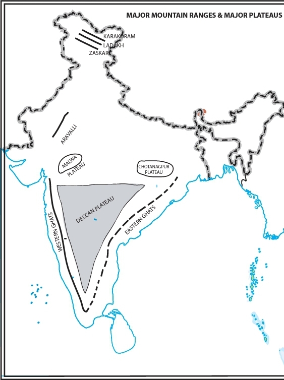
1. Mark the following in the outline map of India-
a) Major mountain ranges – Karakoram, Ladakh, Zaskar, Aravalli, Western Ghats and Eastern Ghats.
b) Major rivers – Indus, Ganga, Brahmaputra, Narmada, Tapti, Mahanadi, Godavari, Krishna and Kaveri.c) Major plateaus – Malwa, Chotanagpur and Deccan.
